


After finishing 2nd in the Kaikoura 2014 GodZone Race, it was our challenge to improve on that result. Roll on 5 months and it was announced that the 2015 race was to be held in our own back yard – Wanaka. Game on. Not only did we have local knowledge but, we had local support and five months to train in the area that would host the event.
We began our preparation for the 2015 GZ by analysing our 2014 performance. We found 5-6 hours of time could be saved just by racing smarter, not physically faster. We were quite excited to implement these changes and reduce the gap on the current GodZone champion team Seagate.
With 55 teams entered in the 2015 GZ including the current number one world ranked team Colombia Vidaraid, the 2014 GZ champions team Seagate and a myriad of other very strong New Zealand teams, 2015 was going to be a very competitive race.
Adventure Racing is a team sport and you can only move as fast as your slowest team member. The slowest member often changes throughout the race as individuals are subjected to extreme physical and mental challenges. We were lucky to have the same team from GZ 2014 competing again in 2015, Bob McLachlan, Simon Bowden, Joanne Williams and Richard Anderson were the 2015 team members racing under the name Team Torpedo 7.
Early on the race organisers decided to throw the competitors a few curve balls. Firstly we were only going to receive one third of the course maps prior to the race start. The rest of the course would be issued during the race. Secondly there were no dark zones for the entire race. Thirdly, there was to be a special orienteering leg, and finally we all had to be up at 3am Saturday morning to catch a bus to a secret start line. This last point effectively meant everyone competing lost an additional night’s sleep, making sleep strategy throughout the race an important factor.
The GodZone is an unassisted race and teams are required to fit ALL of their race equipment including food, clothing and equipment etc into five gear boxes and four bike boxes. It takes considerable planning and time to pack these boxes as no other additional equipment or food can be added after the event begins. It took our team eight hours to prepare our boxes and this was one of the strategies we identified as needing improvement from our 2014 GZ.
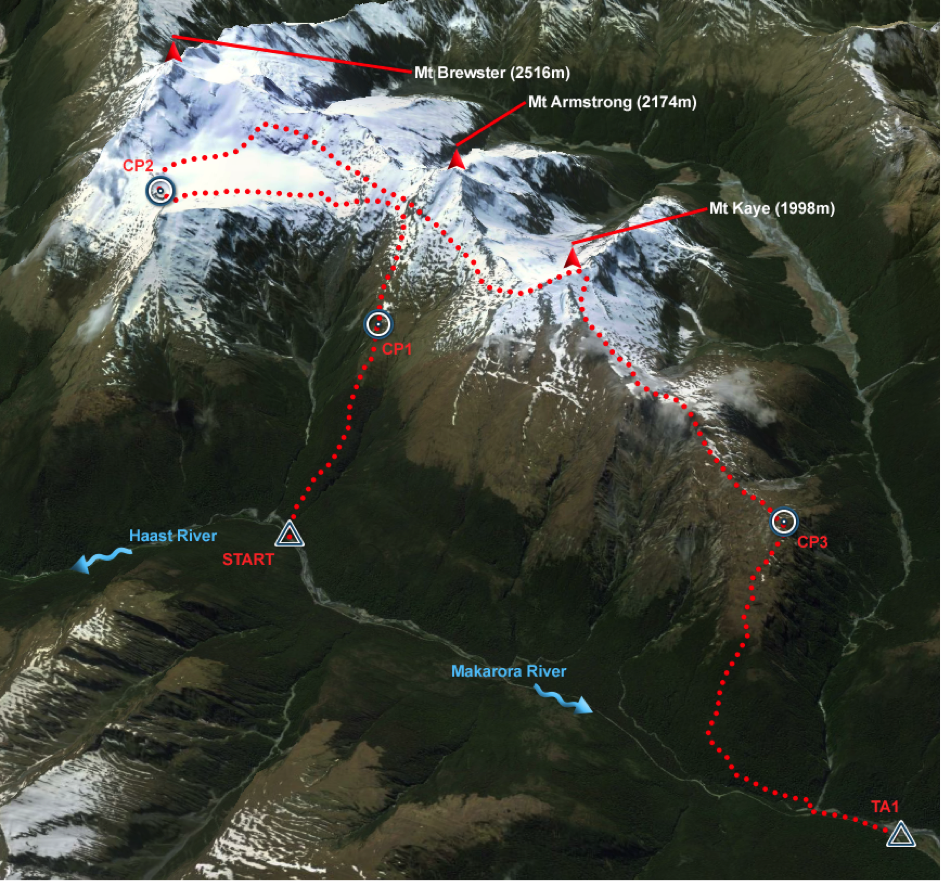
Fast forward to the race start and we find ourselves standing at the spectacular Fantail Falls at the foot of Mt Brewster, in the rain only a few minutes from the start of the race. Had we prepared enough? Were the other teams stronger than us, would the weather be as fine as it had been for past GZ events? Where would the second half of the course go? Could we avoid serious injury to complete the race? These are some of the many question we asked ourselves on the start line.
Read on to find out how a few minutes of daylight could influence our progress by 10 hours and how one mapping error could end our race.
Leg 1 Brewster Glacier
Discipline: Mountaineering
Distance: 22km
Ascent: 2080m
Descent: 2155m
Start: Fantail Falls, Haast Pass Hwy
Finish: Davis Flat, Haas Pass Hwy
Fast time: 06:00 hours
Slow time: 10:00 hours
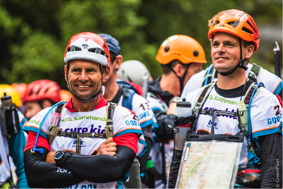
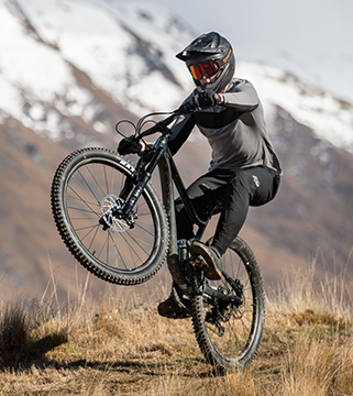
Team Torpedo 7: Bob McLachlan and Richard Anderson at Fantail Falls start line 8am Saturday
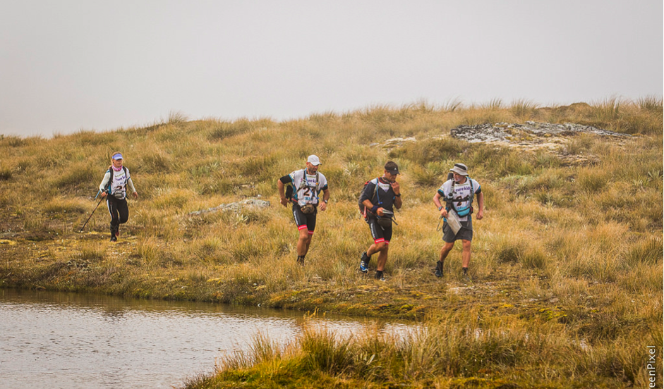
Smiling while it’s raining. A brutally fast start had us racing up Mt Brewster as fast as we could run and climb. We were climbing at 1000 vertical metres per hour with packs including ice axes and crampons into rapidly deteriorating weather conditions. By the time we had reached the glacier the race organisers had wisely decided to cancel the ice trekking leg. This however did not get us out of the weather as we traversed south along the ridge towards Mt Kaye (1998m) before descending into the Upper Makarora River. During the descent Bob took a considerable fall while attempting to descend a bluff. Thankfully Bob was able to take most of the impact though his legs and did not sustain any major injuries.
Leg 2 Makarora River – Canoe
Discipline: Canoe
Distance: 22km
Ascent: 0m
Descent: -150m
Start: Davis Flat, Haast Pass Hwy
Finish: Makarora
Fast time: 3:00 hours
Slow time: 4:30 hours
It was a pleasure to get off our feet and into the canoes for leg 2. We were wise to change into warm clothes as the weather conditions had not improved much throughout the day. Others did not change clothes and were close to hypothermic by the end of leg 2. Unfortunately we did lose our control card during this transition which costs us 10 minutes. That lost 10 minutes would come back to haunt us during leg 7. The remainder of this leg went without difficulty though and while the rain persisted we were in good spirits when we reached Makarora and the long trek leg 3 in 4th position.
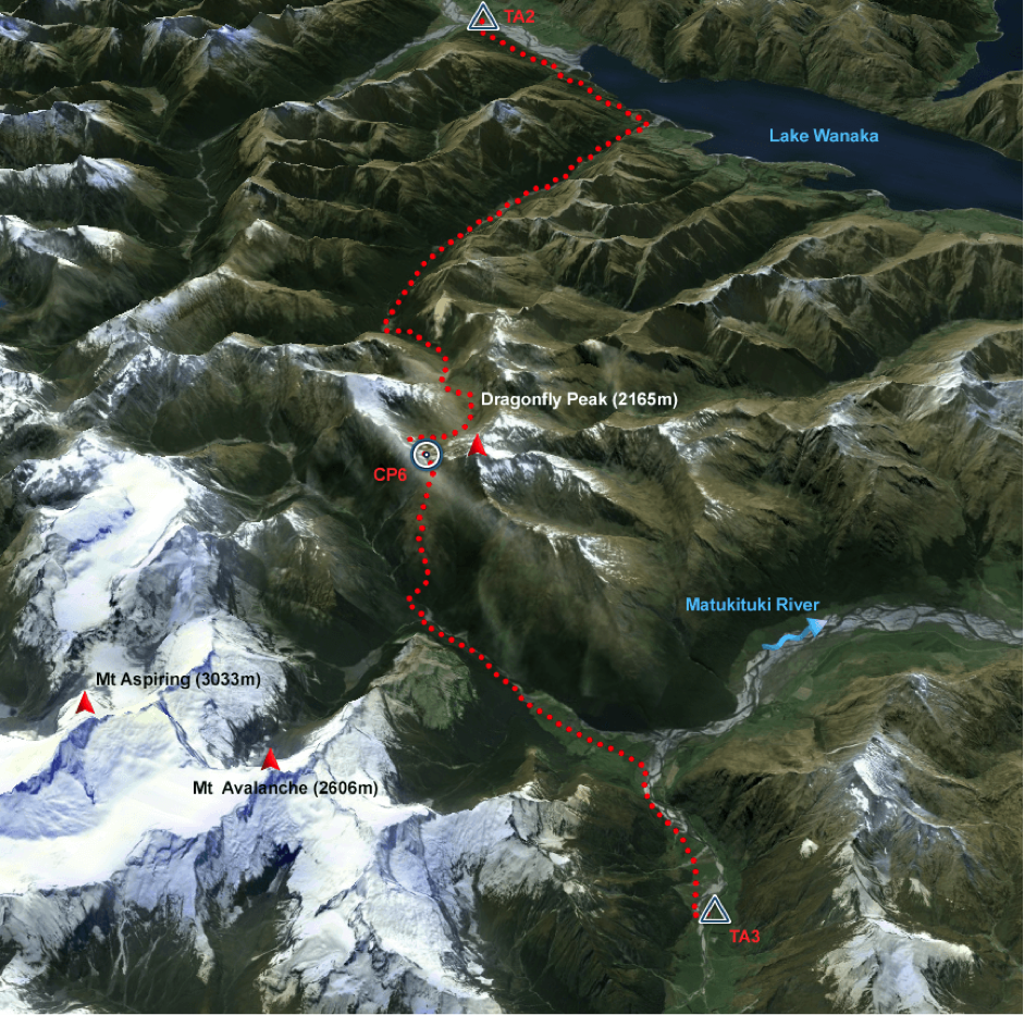
Leg 3 Albert Burn Tramp
Discipline: Mountaineering
Distance: 56km
Ascent: 1800 m
Descent: -1610 m
Start: Makarora
Finish: MacPherson Creek
Fast time: 16:00 hours
Slow time: 26:00 hours
This was to be the one of the longer legs of the race which included two navigation options for the first 10km. Option one was to stay low following the river but risk swimming and soft river bed conditions. Option two was to climb and following an overgrown 4WD track. Given the cold conditions and rapidly rising rivers we choose the 4WD track. Running for the first 10km of this trek got us to the Albert Burn Hut just on dark. We had many more kilometres of untracked valley to follow before reaching a formidable gorge with multiple 20m high waterfalls, very steep terrain and thick scrub. We sidled, climbed and bashed our way over the gorge and grabbed an hours sleep at 4am before pushing on to the Albert Burn Saddle. On daybreak we were pleasantly surprised to see the rain had cleared and it would be a dry run over the saddle and out to the Matukituki River and Transition 3. From the saddle we could see the Matukituki River and we descended fast into the valley floor. The descent was hard on feet, knees and thighs and the run out to the river was more laborious than expected. The tracks were littered with tree roots, slippery rocks and we never travelled in a straight line for more than a few metres. Once again we were pleased to reach the transition in 5th position and looked forward to getting off our feet and into the rafts.
Leg 4 Matukituki River – Canoe
Discipline: Canoe
Distance: 41km
Ascent: 0 m
Descent: -80 m
Start: MacPherson Creek
Finish: Glendhu Bay
Fast time: 5:30 hours
Slow time: 8:30 hours
During leg 3 Richard had sustained a small cut to his right palm during the trek which need medical attention. Small cuts and other flesh injuries can quickly become infected and it was a relief to have a clean dressing applied to the injury at the TA. The canoe leg went well with Simon and Richard showing more boat speed than previous races to keep up with “Big Water Bob” and Jo’s cracking pace. This may well have been due to changing the canoe set up which reduced drag. As we progressed towards Wanaka the weather significantly improved which would be beneficial as the coasteering leg involved promised a chilly 500m swim to the transition at Glendhu Bay. Catching and then passing Team Tiki Tour during the canoe moved us into 4th position once again behind Seagate, Swordfox and Vidaraid. We were met by a significant number of local supporters who cheered us on at the transition and raised our spirits as we set out on the short bike ride back into Wanaka where we were to collect the maps for the remainder of the course.
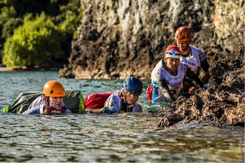
Two members from team Tiki Tour and Bob McLachlan with Simon Bowden during the coasteering
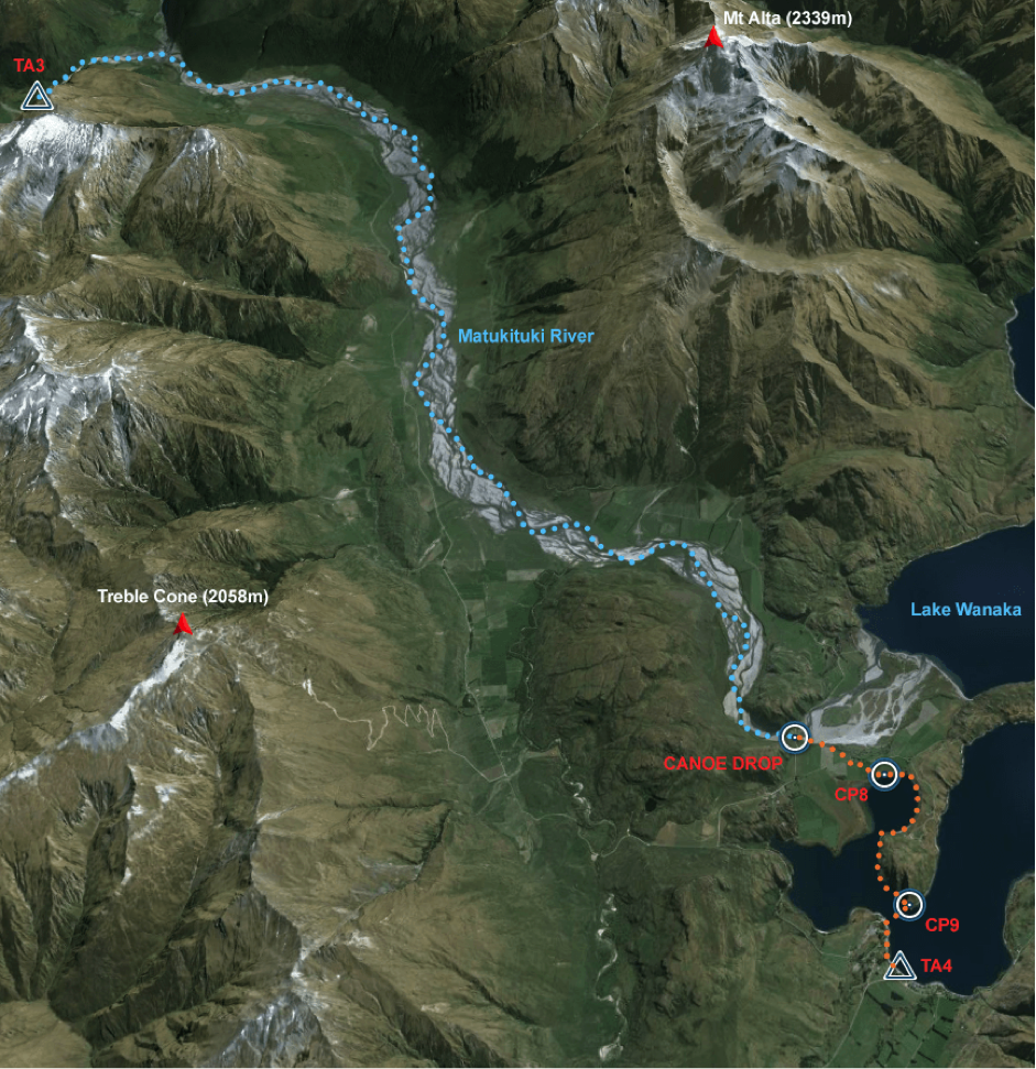
Leg 5 Criffel Range – MTB
Discipline: Mountain Bike
Distance: 137 km
Ascent: 2600 m
Descent: -2520 m
Start: Glendhu Bay
Finish: Driftwood Bay
Fast time: 14:00 hours
Slow time: 28:00 hours
Up until now we had only been issued the first 4 legs of race. We were yet to receive or map the remaining 5 legs of the race. We had hoped that our local knowledge would be an advantage while planning the remaining 5 stages. Was this going to be the case? Arriving at race HQ – the Wanaka Show Grounds – we were issued with a large number of maps and some two hours in the TA to complete the mapping. To summarise the remaining 5 legs of the race were daunting.
During the short bike leg into Wanaka a bolt from Bob’s bike had fallen off and had been lost. This left Bob with just his rear gears to continue should we not be able to find a fix. We decided to head into the Wanaka township to find bike parts and some fish and chips to fuel up on. While in town the public came to our rescue and a bolt was found to secure the shifter. Fuelled up on fish and chips we were back in business.
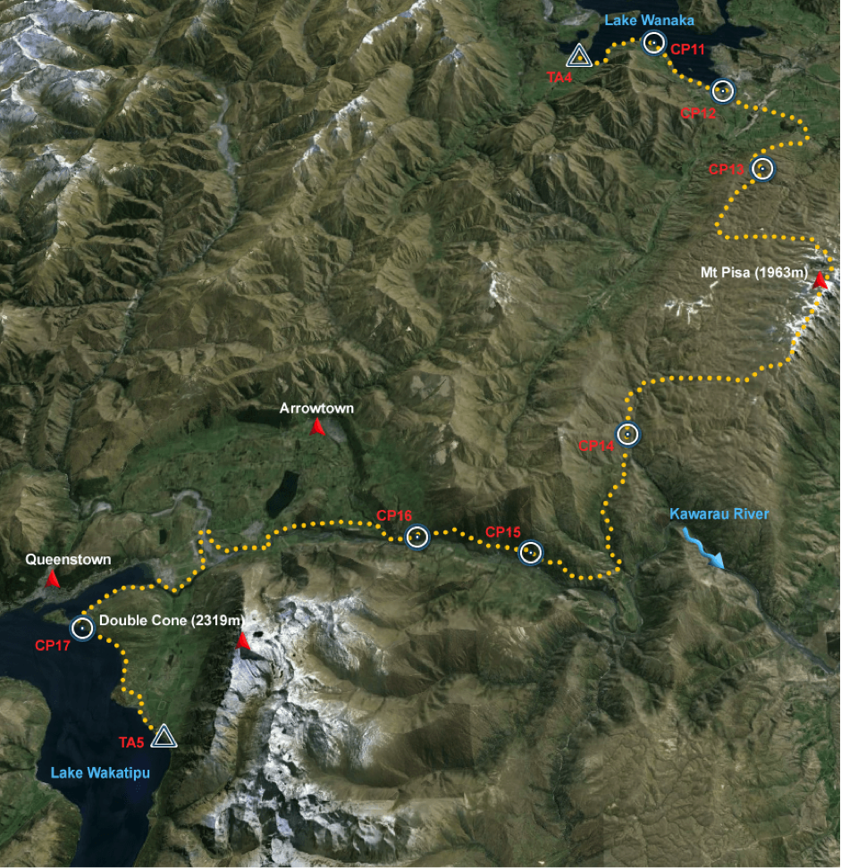
Leg 5 involved a significant climb up the Criffel Range and across the Pisa Range during the night. As it was getting late and rather cold we spent some time finding an abandoned gold miners’ hut to get two hours previous sleep. Unfortunately the hut only had just three walls and the wall facing the incoming weather was the missing wall – but it was better than no shelter at all. Later that morning we encountered some of the worst weather for the event. At near 1950m the weather turned bad and we were enduring winds strong enough to blow us to a stand-still. We all took shelter behind rocks and put on every item of clothing we had to be able to continue. Fortunately as the day went on the southerly passed and we enjoyed some warmer weather, however this was not to last and another late shower had us soaked when we reached the end of the leg at Driftwood Bay around 7pm Monday night still in 4th position.
Leg 5 went well for us. We encountered two southerly fronts but we had made steady progress and quickly found all the check points.
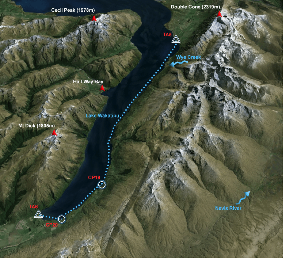
Leg 6 Wakatipu – Kayak
Discipline: Kayak
Distance: 28 km
Ascent: 0 m
Descent: 0 m
Start: Driftwood Bay
Finish: Kingston
Fast time: 3:30 hours
Slow time: 5:00 hours
We were fortunate to start the kayak leg in the day light and with just a light head wind. Lake Wakatipu is well known for it’s windy and choppy conditions. Kayak navigation at night is always hard, as there are fewer features that can be used to plot progress. We managed to kayak far enough down the lake in daylight to reach a point where we could hug the coast and begin searching for the two check points located on the south side of the lake. As darkness fell the wind picked up and we completed the second half of the kayak in challenging, cold and wet conditions.
There was little reprieve from the cold conditions. In Kinsgston as we went through our transition very early in the morning there was a near freezing mist blowing though the town. We were well looked after by the TA staff who supplied us with hot soup and pies. Having changed out of our wet kayaking clothing and into out tramping gear it was time to find some shelter and get a two hours sleep. We bedded down in a vacant firewood lean-to that had a surprisingly comfortable pebble floor. Once again we only had three walls but any shelter is better than none. It was noted that the Team Captain set a new recorded for snoring much to the frustration of his team mates.
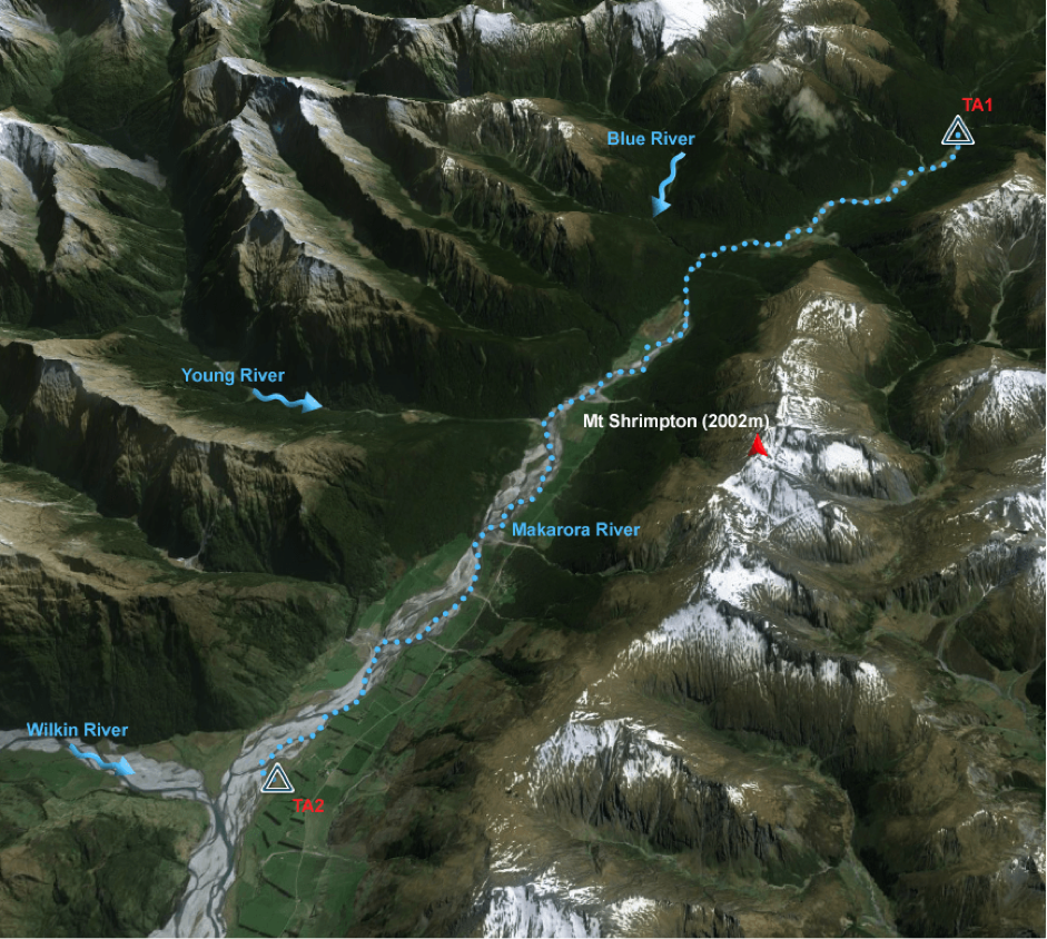
Leg 7 Garvie mountains – Tramp
Discipline: Mountain Trek
Distance: 47 km
Ascent: 2930 m
Descent: -3030 m
Start: Kingston
Finish: Piano Flat
Fast time: 15:00 hours
Slow time: 28:00 hours
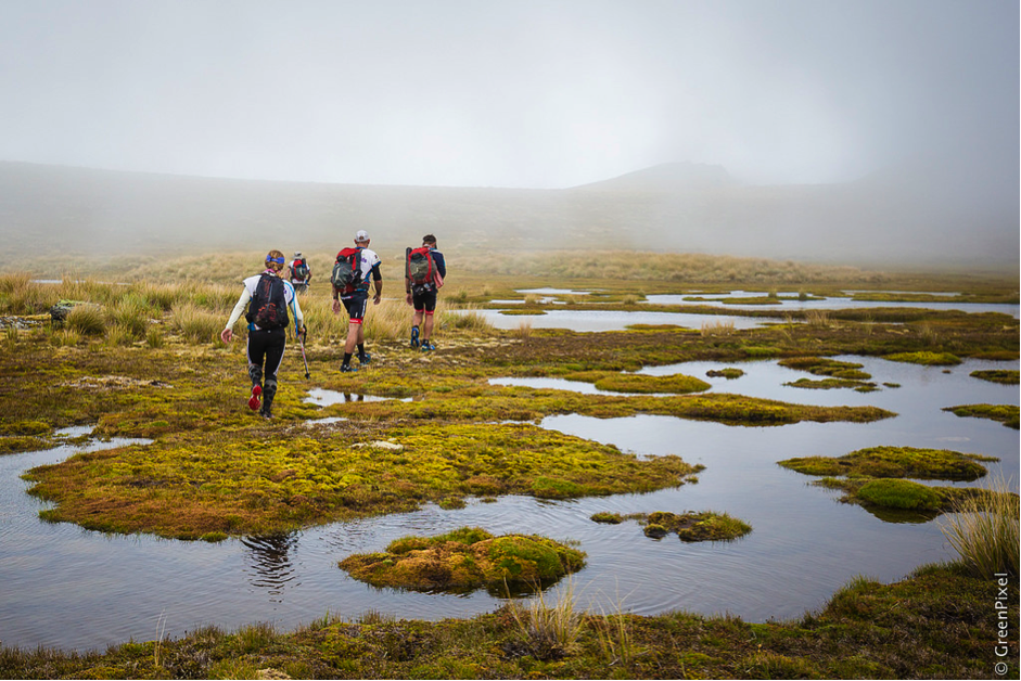
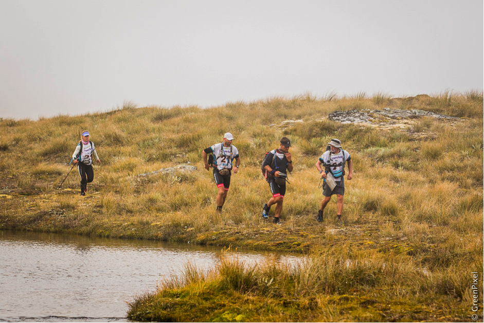
Any thoughts of some local advantage were now completely gone. I doubt anyone competing in the 2015 GZ expect the race to travel as far south as Kingston and the Garvie Range. We were all entering new country and a big reason why we do this sport – for the adventure.
After some exceptionally beautiful landscapes and crossing multiple ranges we were only 4Km from connecting with a DOC track that would lead us to the TA when the mist rolled in. With very little visibility we were forced to proceed by compass bearing only. The terrain had very few features to confirm our exact location, and devastatingly, we missed the connection with our track by 150m. Dark had fallen and the fog was staying put. We searched for the track for four hours and decided to put up the tent and wait the night out. Come morning the mist lifted and we quickly found our trail and ran to the TA. How many places had we lost? Tired, frustrated, anxious and disappointed were some of the emotions we felt while descending into the TA. On arrival we were pleased to hear only three teams had left the TA, however there were two other teams at the transition with us. Few words were spoken amongst teams and team members. Everyone was showing the signs of severe fatigue. We had a good transition and it was a pleasure to be on the bike using different muscles and wearing dry clothing and footwear.
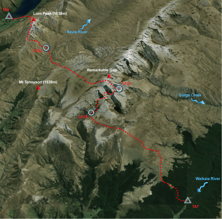
Leg 8 – Old Man Range – foot orienteering and MTB
New to the race for 2015 was a specialist orienteering section. This leg was to utilize a specialised high detail map specifically made for orienteering, to be completed on foot, as part of the larger stage 7 MTB leg. While cycling we chose to carry additional shoes for use when orienteering. This was to be a good decision as the terrain was rough and bike shoes would have been very uncomfortable for travel on foot. Initially we were anxious about the orienteering leg and we had a slow start, however as we became more familiar with the map and it’s accuracy we found this to be the easiest navigation leg of the race. While completing the orienteering we noted fatigue and injuries starting to show on the other two teams.
After completing the orienteering we had a significant bike push up to the tops of the Old Man Range. As there was little water for the next 50km and it was turning into a very hot day we were all concerned about dehydration. Given the white out conditions we had faced the previous night and extreme cold during the Pisa bike leg we were all motivated to get off the mountains as soon as we could. We pushed hard all night to reach the relative safety of Duffers Saddle just south of Bannockburn. On route to the end of the leg at Dublin Bay we pinned our ears back and headed for home to meet disaster.
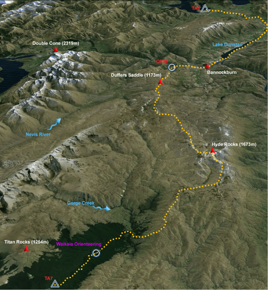
Upon reaching Dublin Bay we were informed buy race officials that we were now 3rd, behind Seagate and Vidaraid, however we had missed a CP some 50Km back near Duffers Saddle – Bannockburn. It was hard to believe that three days prior we had made a simple mistake while mapping the second half of the course. The irony of the situation was that we all knew the location of the missed CP as it was a popular cycling track that we had all ridden previously…..… we simply did not map it. We estimated that it would have added 20 minutes to our bike leg should we have mapped and followed the correct route. We were now faced with two options. Go back and get the CP – a 100km round trip and some 600m of climbing, and most likely lose one maybe two places but still be 5th or 6th. Or we could complete the last leg and be unranked. Perhaps it was the fact we were so close to our home town, our own beds and the finish line were calling us, so we chose to finish unranked.
Leg 9 Lake Wanaka – Kayak
Discipline: Kayak
Distance: 52 km
Ascent: 30 m
Descent: -30 m
Start: Dublin Bay
Finish: Rugby Football Club, Wanaka
Fast time: 7:00 hours
Slow time: 10:00 hours
From 3rd overall to unranked we took our time in the transition. It was lovely to see so many friends and family show up at 4am to support us embark on the final leg. We had the fastest time for the last two legs 7 and 8 and crossed the line only 45 minutes behind the current number 1 ranked team in the world Columbia Vidaraid. We were swamped by supporters and well-wishers. At that time just finishing was a relief and the final results did not seem to matter much. A short time later and while recording this race report I’m not feeling quite so satisfied. There are always many small variables that can influence the outcomes of such a long and arduous race. Some are lessons, some are luck and some are fate. What could have been if we had not lost our control card back in TA1 and gained 10 minutes of day light while we looked for the DOC track? We certainly learned that for all future races we need to check off all our CP’s next time we are mapping new parts of the course. When you list the “what could have been” scenarios during an adventure race, I expect every team has their own story to tell. I do however believe that the best teams in the world have the shortest story and that’s why they are the best.
Adventure Racing is about as arduous as you can get. The 2015 GZ was the one that got away. Yes we finished unranked, but in our hearts we finished 3rd behind the two highest ranked teams in the world. A result we are all immensely proud of.
Thank you to our sponsors – Torpedo 7, Mike Greer Homes, Salomon, Racers Edge and Absolute Wilderness foods. Thank you to our army of supporters, family and the people that help make this happen. We hope we made you proud.
Thanks to the whole of the Torpedo7 Adventure Race team, you certainly did us proud in 2015. Richard Anderson, Simon Bowden, Bob McLachlan & Jo Williams, you guys rock!!